NASA’s Landsat satellites have consistently made history in Earth observation since the project’s first launch in 1972, with this year marking 50 years of innovation and science. Its influence may surprise you, as will its continued relevance in the face of a fast-growing commercial imaging satellite sector.
Landsat may be a familiar name to you but doesn’t ring any particular bells. It’s understandable — there are a ton of NASA satellites up there looking down on the planet. But the easiest way to say it is this: In 1972, Landsat basically invented modern Earth observation. Then, remember a while back when every Google Earth image said “USGS” on it? Yeah, that was Landsat too. The project has basically ushered satellite imaging from bleeding edge research tool to everyday technology.
Landsat 9 just launched last September, the latest in a long line of influential spacecraft.

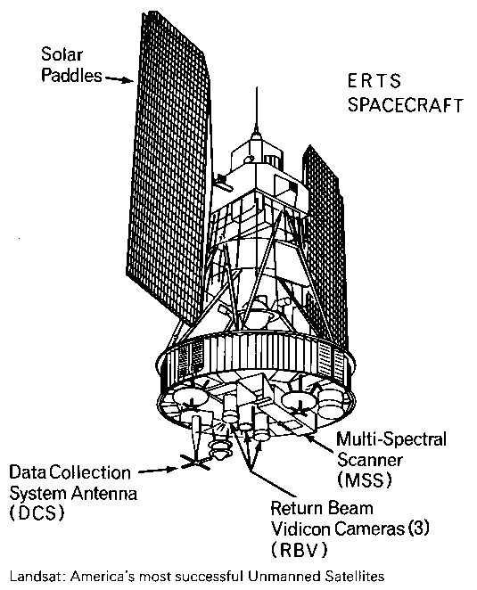
A schematic sketch of Landsat-1. Image Credits: NASA
I talked with Jim Irons, who has worked at NASA since 1978 and on Landsat since 1992. Irons told the story of Landsat from the beginning, both what he took part in himself and the lore he’s absorbed over the years. It’s fitting that for a project that would redefine Earth imaging, its very first satellite was both innovative and historically significant.
“Landsat 1 launched in 1972 — it carried two instruments, one was the Return Beam Vidicon, and it was kind of like a TV camera, it took analog data,” Irons said. “But Hughes [Aircraft Company] convinced NASA to put another instrument on the payload that was more experimental: the Multi-Spectrum Scanner. And it provided digital data.”
It hardly needs to be said that in 1972, digital anything was pretty innovative, let alone high-performance digital sensors in orbit. But the team clearly saw the writing on the wall, and good thing too.
“After launch, the RBV had problems, and the data from the MSS became the preferred data. That was a big turning point,” recalled Irons. “It was an instrument that used an oscillating mirror that went back and forth to scan a path at 7-14 Hz, underneath the orbital path of the sensor, to create a digital image. And it’s mechanical! It was amazing.”
“The designer of this sensor, Virginia Norwood, she’s still with us, in her 90s. It was very unusual at the time to have a female engineer at all. She came to the launch of Landsat 9 last month, actually.”

Virginia Norwood (photo taken in 1972) with the MSS instrument she created. Image Credits: NASA
It’s a remarkable fact that the beginning of the orbital imaging revolution was the brainchild of one of the then-rare women in the space and tech industries, whose roles in many of the era’s important accomplishments have only recently begun to be given the attention they deserve. You can read more about Norwood’s role in the creation of the MSS, which is the precursor to many more such systems, at this NASA history article, or this more recent piece.
A successor to the MSS called the Thematic Mapper launched in 1982 with more spectral bands, but then in 1984 another big improvement struck a nerve at HQ:
“Landsat 5 in 1984 carried both a multispectral scanner and advancement on the thematic mapper idea that improved the spatial resolution of the data, from what had been 80 meters with the MSS to 30 meters, and spectral bands were added,” Irons said. “But there was all this data! Some people were afraid of that data, that analysts would be overwhelmed by it — but it didn’t turn out that way. Computer capacities kept up and soon the thematic mapper data was preferred.”

Image Credits: NASA
That would prove a rule as time went on and right up until the present: There really is no such thing as too much data. As long as you can collect it and store it, someone will find a use for it.
They might even pay you for it — but an attempt to privatize Landsat in the following years fell flat, or burned up on reentry in the case of Landsat 6, which never made it to orbit. Meanwhile, the private company created to operate and distribute the rest of the data jacked up the price until no one was willing to pay any more. “It was up to $4,400 per scene of thematic mapper data. People just stopped using it,” Irons said.
When NASA and the USGS, which handled the distribution of the imagery originally, returned to the reins, they had an international data recovery problem. Imagine having reams of data in a ground station in China or South America, long before ubiquitous broadband networks. How do you get it back to HQ in the States for central processing and analysis? I told Irons I was picturing big trucks full of hard drives, the internal combustion equivalent of Sneakernet.
“That’s exactly what happened!” he laughed. “They just drove up to the [USGS] facility with semi truck trailers full of magnetic tapes. It was difficult because they had all these different formats and instruments. So that created a little chaos. They bought pizza ovens to bake the water out of some of those tapes.” (I wanted to hear more about that part but our time was limited.)

Image Credits: NASA
But the repatriation of the data was only a precursor to an even larger shift.
“After Landsat 7 launched was perhaps the biggest change in the entire program,” Irons said. “USGS was still charging $600 for a mapper scene of data. And they made made what I consider an institutionally brave decision in 2008, to be consistent with NASA and provide Landsat data at no cost to anyone who wanted it. So it went from $400 to $600 to free.”
As you can imagine, this choice completely upended the model, and overnight, it changed everything.
“There was an explosion of use and redistribution of the data,” he continued. “Now, some places like Google Earth and Amazon Cloud Services, they’d gone in and downloaded the whole archive from USGS.”

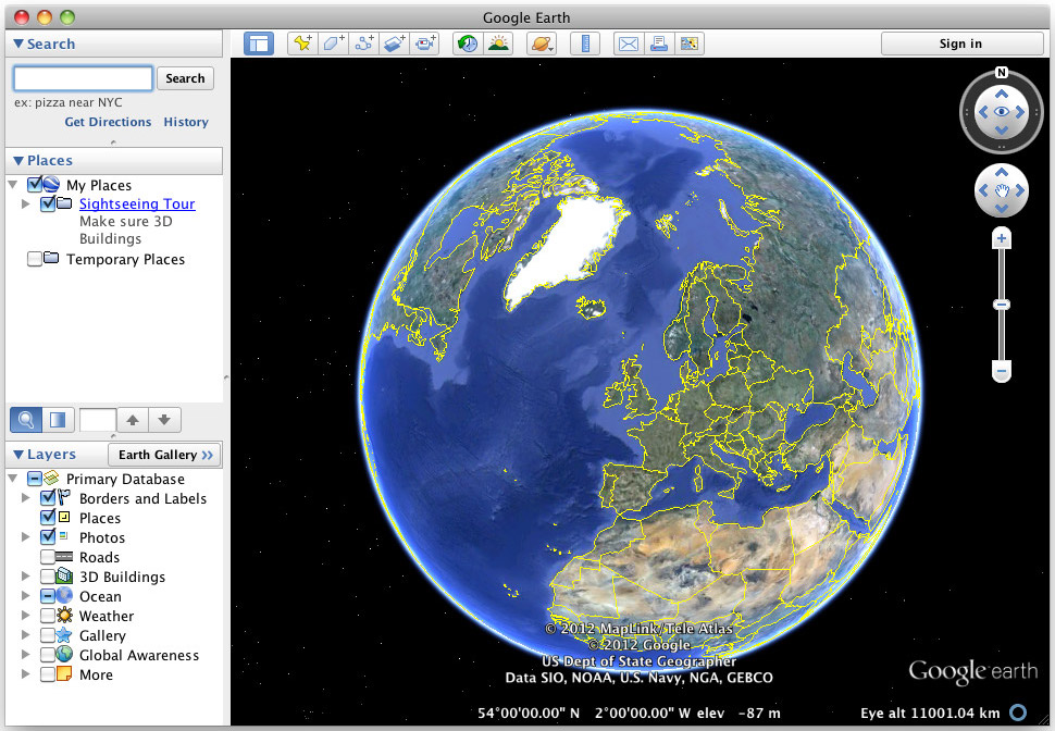
Remember the old Google Earth app? Image Credits: Google
That’s why for years, whenever you looked at an online map, it credited the USGS. Of course Google and Amazon didn’t own the imagery, or capture it themselves, though now all the majors are doing that at various scales. They simply downloaded a huge picture of the entire Earth and re-served it to their customers in a new form.
“It’s a struggle for us to brand the data and the program so taxpayers know they’re getting their money’s worth,” admitted Irons. It’s not like every time you opened Google Maps, it thanked you for making their business possible!
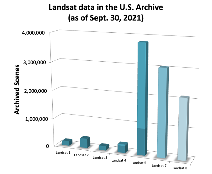
In the years since, Landsat 8 and 9 have launched with improved sensors and continued to collect invaluable data that is continuous with the previous decades — a free, long-term database of a large portion of the planet imaged every couple weeks or so depending on the era.

Image Credits: NASA
Of course nowadays constellations like Planet’s are imaging the whole globe on a daily basis. So why have Landsat at all?
“Those of us who work on Landsat are very impressed by what the commercial providers have achieved,” Irons said. “The message we want to get out is that Landsat is complementary to that data — they don’t replace Landsat data. One, it’s open and transparent access — that’s key, and it’s true of all the data collected by NASA satellites.
“Two, the USGS has maintained this 50-year archive of data. Is there a business case for companies to archive their data for decades, so we can observe the effects of climate change over the long term rather than just have short bursts of data? I don’t know that the business case is there.”
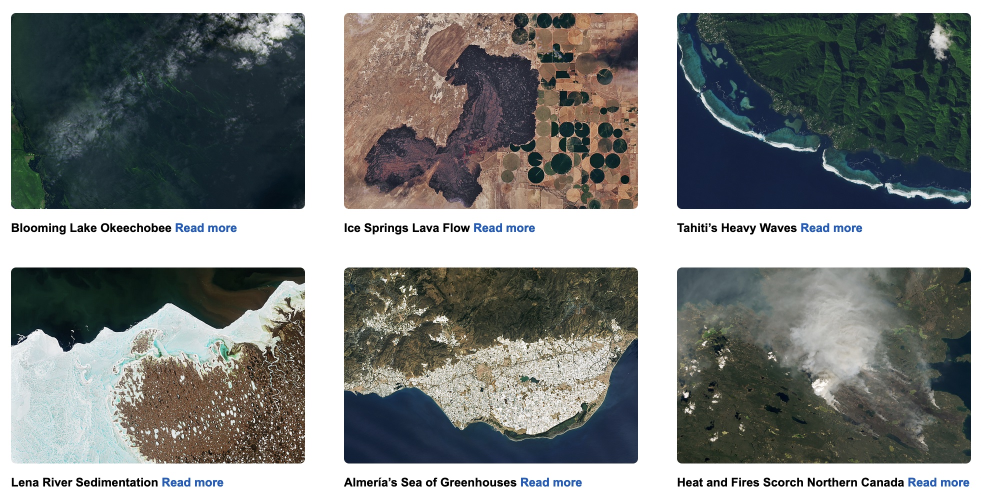
You can see an example of what decades of continuous data looks like here:
“And one of the things that enables our time series analyses is that NASA pays a great deal of attention to inter-sensor calibration,” Irons continued. “If you’re going from one Landsat image to another, you know it’s been calibrated — if you see a change over time, you can be clear that the thing is changing rather than the camera. [Commercial constellations] use Landsat data to do that; we serve as an industry standard to help them do their calibration.”
Here the conversation overlapped with what I talked about with Ginger Butcher, who’s done outreach for the project for years.
“We can compare a Landsat image today to a Landsat image from 1972,” she said. “That’s one of the tenets of the program: We have a dedicated calibration team keeping an eye on the instruments. Every full moon we turn the spacecraft around to use it as a kind of photographer’s grey card.”
With the increasing prominence of commercial providers in the U.S. space program, it was a real question over the last few years whether Landsat was worthwhile to continue funding, but arguments like those above won out.
“We used to have to work really hard to get that next mission, but now we’ve basically got the government saying this is a valuable resource worth continuing with,” Butcher said. “Now we’re looking to the future and what kind of capabilities we want to get out of the next Landsat. What kind of research are people doing? What additional wavelengths are needed for work on ice, or on forests, or particular areas in agriculture? For example, with thermal data we can look at crops and see if they’re being overwatered or underwatered — with water rights out west, that’s really important. As scientists take on new questions and new areas of study, they divine where Landsat goes next.”
More than ever, the project will work collaboratively with the commercial sector and with ESA satellites like Sentinel-2.
“We think it’s great,” said Irons. “The emergence of all these systems means the Landsat project has been incredibly successful; it basically created the market for them.”
from TechCrunch https://ift.tt/SrDg531
via Technology
Comments
Post a Comment